Introduction
Tracking the debates on the existence of Tanah Runcuk was initially an exhausting scientific attempt. The lack of domestic data resources once again made the unravelment of the mystery evaporate and forgotten, or at least, replaced by the issues closer to the interest of the market and the ruler. Indeed, the final question will always be about whether it is still relevant to discuss and (publicly) adduce this issue.
Such concern was eventually answered after Ludwig Stern Jr. and Kreuzer Wallach’s travel literature was discovered and secured for further studies in 2006. The formation of a joint team consisting a number of interdisciplinary researchers from some universities in Europe and Southeast Asia, widely known as the Centre for Tanah Runcuk Studies (CTRS), had at least restored hope of and longing for questions and mysteries related to Tanah Runcuk. Investigations and studies on Tanah Runcuk are expected to be able to extend the spectrum of perusal upon the history of Nusantara, and to provide another entry into the historiography of Indonesia which has tended to be the state ideological apparatus hitherto, while lacking of alternative discourses (even until today, 16 years after the New Order was overthrown).
In this writing, I would like to process and conduct some analyses departing from Stern Jr. and Wallach’s data on Aom People, an exclusive community residing in the northern part of Tanah Runcuk, precisely in what researchers and experts on Tanah Runcuk called as the “Triangle of Death”. All hypotheses and explanations presented herein are temporary. They will always be developing according to the findings and data analysis result performed by CTRS team based in Indonesia, Chicago, and Weimar.
Aom People in the Triangle of Death
There was a group of people inhabiting the area of the Triangle of Death. They were known as Orang Aom (Aom people). There were no many data or records on Orang Aom since they lived exclusively. Moreover, it was difficult to meet them because they resided in the Triangle of Death, which was a quite unaccessible area due to its dangerous and strenuous geographical condition. However, Orang Aom were believed to have another specific route to access the world outside; and not all of them knew about it. There were only few persons given the trust to work as hunter and the elders who were familiar with this secret route.
Stern Jr. And Wallach collected the data on Orang Aom through a series of observation of Orang Aom who had been alienated by their community(1). According to Stern Jr. and Wallach, Orang Aom were alienated from the community when they were considered to break the custom. They were cast away from the Land of Aom by the “hunter class”. Before being exiled, the guilty Orang Aom would be judged with customary law, then stupefied with some traditional potions. Such methods aimed at making the persons lose the track to return to the community. While death penalty was imposed to the member of hunter class who broke the custom. Orang Aom could not read map. They recognized their natural routes from hereditary journeys and the signs left in the jungle, such as rocks or cave. Stern Jr. and Wallach recorded that there was never any expedition succeeded in finding the land of Aom, nor did they.
Alienated Orang Aom later gathered and created a new civilization which was more inclusive, instead. These alienated groups managed to accept the cultures from outside, and started to learn speaking in other languages (other than Aom language) and living with the outsiders.
The Model of Orang Aom’s Societal Structure
Aom people were divided into five groups called “mata”. Those five mata(s) were Mata Singga, Hanim, Ruja, Angka, and Horo. They formed groups because of several reasons, among others:
- Finding no land which was wide enough for the entire tribe to settle;
- Plantation fields were not enough to produce the food needed by the whole society;
- There was a customary taboo restricting them to change the natural topography—minimizing the consumption of natural resources as much as possible.
One mata consisted of approximately 50 citizens and was led by the chief of mata called maramata. The division of mata was not performed based on lineage, but on the distribution of expertise. If a mata encountered a lack of workman, they would ask for citizens to other mata(s). Such social system was proved to minimize conflict within the community. It was beneficial, particularly for the need of information exchange.
Aom People’s Migration Pattern
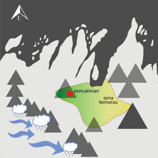
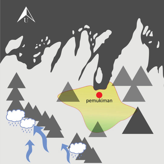
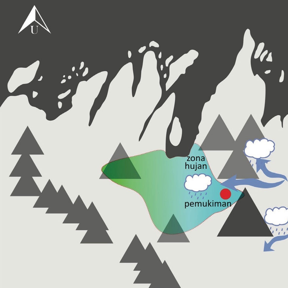
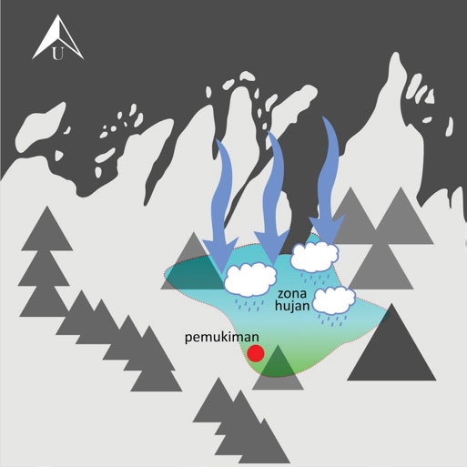
Orang Aom’s life pattern strongly depended on geographical condition. Season changing in every three months resulted in extreme change in weather. In south and east seasons, rain clouds were restrained around The Ceaseless Mountains, thus the area of the Triangle of Death encountered a prolonged drought. Otherwise, in north and west seasons, rainfall extremely increased.
The ancestors of Orang Aom overcame this climate problem by living nomadically. They looked for locations with ideal climate. As time went by, they had found some locations ideal for settlement, which were later called as Soak Bare (North Land), Soak Ramu (East Land), Soak Lipur (South Land), and Soak Minggu (West Land). Each location had different house characteristic and model, adjusted to the geographical condition. It was quite unfortunate that Orang Aom could not read map; it caused a difficulty for the study team to ensure precisely the location of Orang Aom community.
The more modern Aom people lived in seminomadic way, which means that they remained moving every three months but each location had already had a permanent structure that had been emptied for nine previous months. They had performed an agriculture system manifested in “grow-and-go” model: they gathered grains, tubers, and buds to grow. The plants would be ready for harvest in the next year, when the people had completed one round of migration. Orang Aom did not know barn because they did not need to store foodstuffs, indeed. The foodstuffs they were going to cook were directly taken from the harvested crops or the game meat. Orang Aom did not have any recipe of foodstuffs to use or combine, therefore they had never experienced shortage of food nor did they have any leftover.
Aom people believed that they were the people whom God trusted to keep the land of heaven or the ancestral land located in Aom Valley. This was the very reason why they remained living in the same environment which ironically forced them to move, regardless the fact that they knew how to move out from the Triangle of Death.
The Influence of Philosophy towards Orang Aom’s Vernacular Architecture
The rite of migration is an implementation of the philosophy of life which have been conducted through generations. Orang Aom migrated to visit and honour the guarding/ruling spirits in the four areas, with the reference of the mystical-imaginary axis (Kawaruncing Volcano–Mount Tanatombak as the supernatural territorials, the higher stratum, the land of the high god—the land for the sacred; Tajambibir Hill–Muara S. Kopi Tombak Bay, the stratum on which humans live and gain food from nature; and the area of The Ceaseless Mountains–Mount Karasdendam as the land of abstinence, purifying self from worldly sins). As the logical consequence, such cosmic consciousness kept Orang Aom away from excessive exploitation over the forest within this zone. Within Orang Aom’s level of mystical concsiousness, each location had different philosophical dimension. It was represented in the model of uma (rumah/house) that was always adaptive, adjusted to various ecologies and topographies in each point of settlement displacement. Every model of uma was absolutely determined by Orang Aom’s cosmological aspect.
Orang Aom believed that their ancestors were born from the direction of the rising sun. Such belief made the East Land a sacred place. The area became the place where Orang Aom performed various rituals bestowed upon the ancestors. Otherwise, the West Land was the place for abstinence. Here, Orang Aom lived in the sacred grove and did fasting.
The west-east axis was where many unworldly activities took place, thus Orang Aom were not allowed to leave any trace when they left the West Land or the East Land. Meanwhile, the North Land and the South Land were the lands of grace given to Orang Aom. That was why Uma Ramu and Uma Minggu were nonpermanent, different from Uma Bare and Uma Lipur which had more permanent structure. Towards Uma Ramu and Uma Minggu, people only removed banua (wall and roof) when they were about to leave the land, while the main structure was left standing.
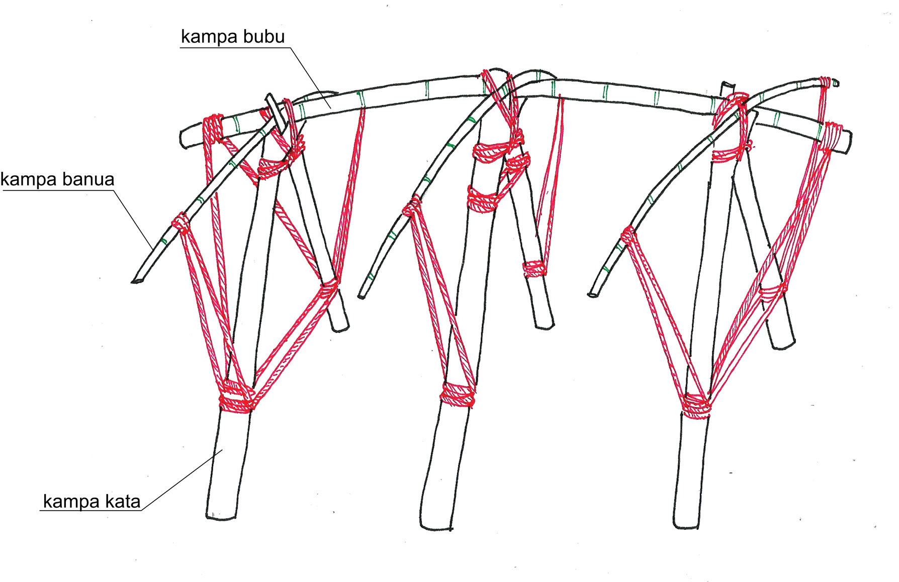
The primary subject of the achitectural model of Uma Aom was its joints that did not use any nail. However, it was not similar to austronesian houses in common—applying the concept of lingam-yoni or interlock system such as tumpang sari(2) in Javanese joglo (traditional house). Uma Aom mostly used knot and rope as the substitute of blocks that received the tensile strength. The ropes were made of knitted roots, by women. Orang Aom had a great number of diverse knots for each type of joint. A rope joint was considered more effective for a nonpermanent or semipermanent structure because, moreover, Orang Aom did not seem to know how to process the materials so that it would be more sustainable. It had implications for the structure of Uma Bare and Uma Lipur that required regular renewals.
The wall filler and roof materials of Uma were made of the arrangement of various leaves, commonly the palm leaves. This leaves arrangement was called banua. Banua could only be used for one period of settlement. However, the interesting part is that they only needed 1-2 days to prepare the entire settlement of a mata.
Soak Minggu (West Land)
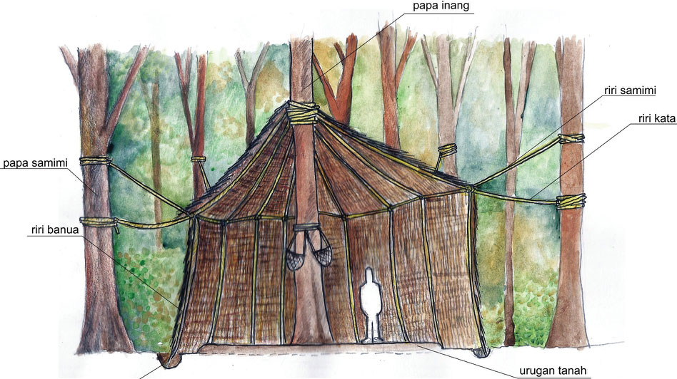
The settlement of the West Land was located within the sacred grove. It means that Orang Aom were not allowed to cut down the trees and could only utilize the branches or the trunks of dead trees. This ecological consideration impacted on the structure of Uma Minggu which did not use any hard (trunk) at all. Instead, it relied on the ropes tied to living trees.
The main tree functioning as the most important structure was called Papa Inang. With Papa Inang as the axis, ropes were stretched to all directions and tied to the closest trees (Papa Samimi). The ropes were knotted one another so that they could attach the wall and roof materials. Such structure was actually very rickety and shaky, but fortunately, during the period of settlement in this location, there was never any strong wind; and they lived within a very dense forest.
The pattern of house arrangement in Soak Minggu tended to be random. There was no rule of orientation or extent of the house. The structure completely relied on the composition of existing trees. Orang Aom comprehended such randomness as the form of complete surrender to what their god had given.
Soak Bare (North Land)
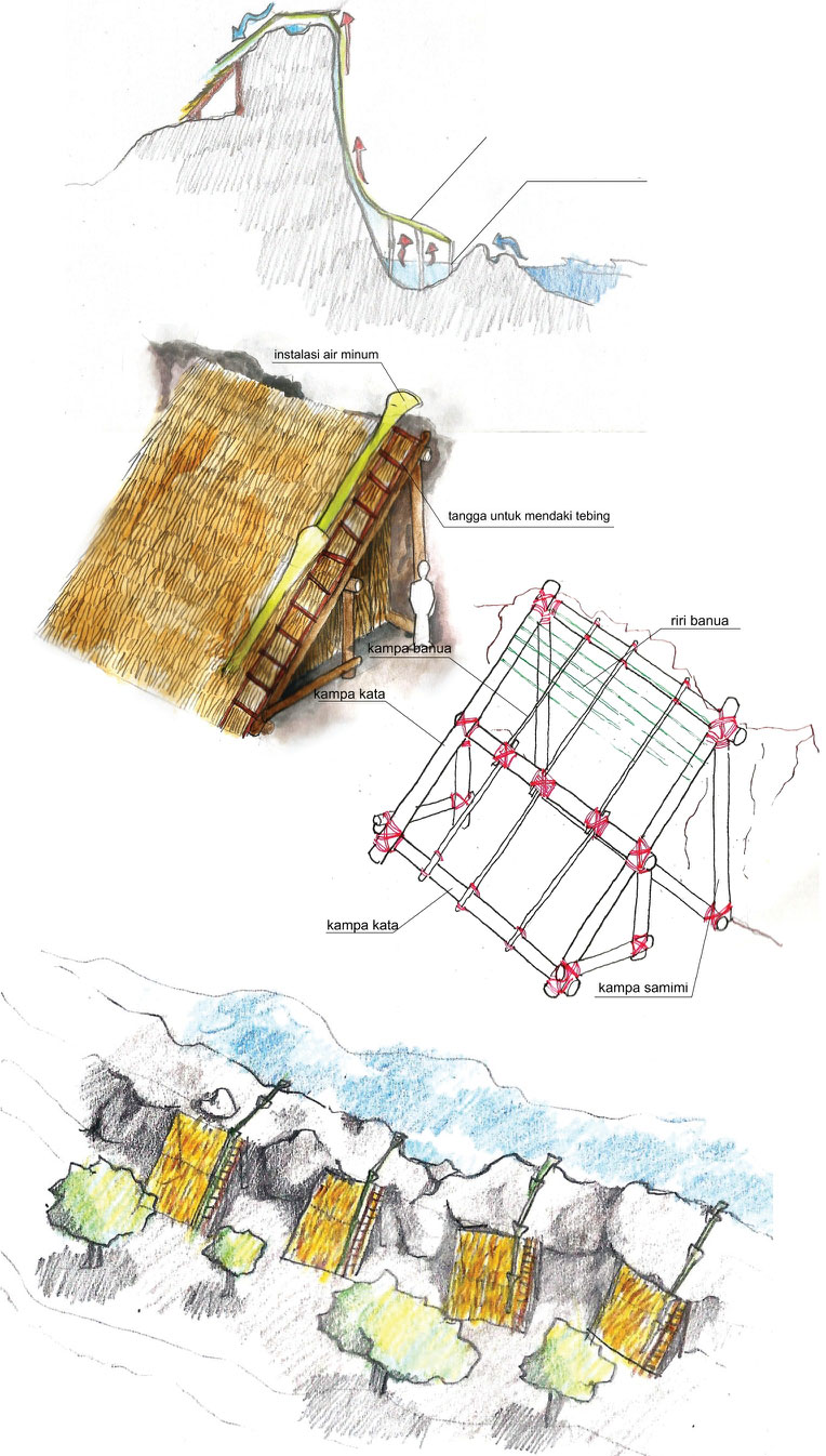
Orang Aom inhabited Soak Bare in the season of the south wind, when almost all areas of the Triangle of Death encountered drought and water shortage. Around estuary, some water was drinkable, but Orang Aom chose to make an installation system to increase the supply of drinkable water. They performed seawater distillation, by using a technique called Kabaranohu Umpe, which flowed automatically to each house.
Orang Aom did not have maritime culture, thus they did not know about ship. Therefore, they did not choose to live around the coastal lowland. Their settlement was located on the steep cliffs adjacent to the sea. The cliffs with the sea behind functioned to prevent damages when the north wind strongly blew. It was because the main structure of Uma Bare was usually left assembled.
The structure of Uma Bare relied on the cliff. The main structure consisted of four main pillars (kampa kata) arranged to form a plane which was then leant on stone wall. The need of this stone wall led to a housing pattern that lined up from west to east.
Soak Ramu (East Land)
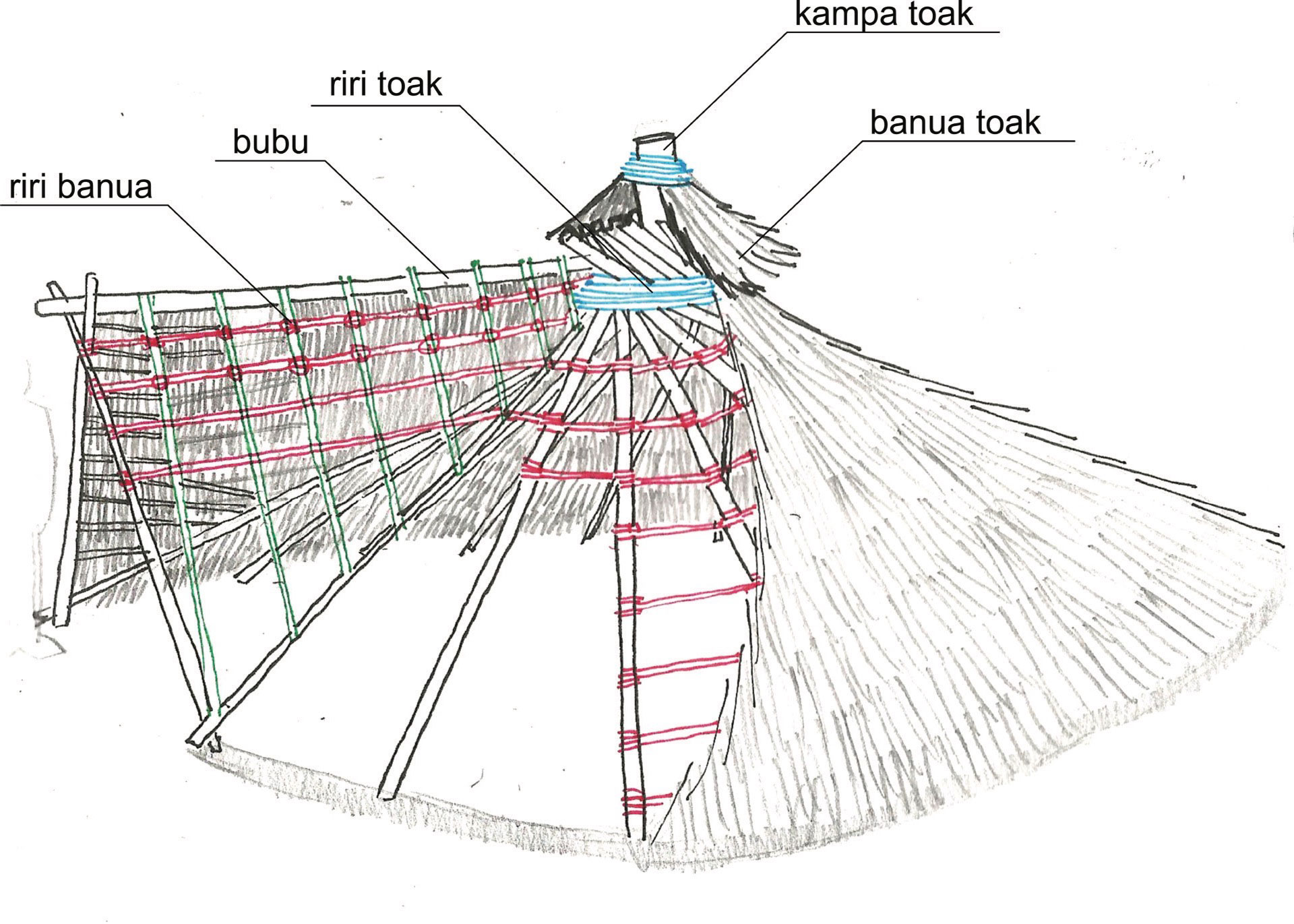
The East Land was the sacred land, where Orang Aom performed many rituals bestowed upon their ancestors. Geographically, it consisted of savanna flanked by Mount Kawaruncing and Rumpunkelok Mountains. As happened in the West Land, uma in the East Land was not allowed to be permanent and it should be removed when they were about to leave. Since it was located around savanna, the model of the uma could not rely on natural objects such as forest, stone wall, or ground contour. The structure of Uma Ramu could stand on its own.
The shape of Uma Ramu was quite simple, resembling a tent. The problem they frequently encountered was a quite strong east wind. Therefore, Uma Ramu was relatively low in order to avoid large lateral load. Consequently, all indoor activities were conducted by sitting, and the door was always facing west. The materials were small trunks, with the diameter around 8-12 centimeters, that was burried half a meter deep. After dismantling the house, good trunks would be kept for the next period. Worn trunks were then burnt together with the firewoods for the sake of rituals.
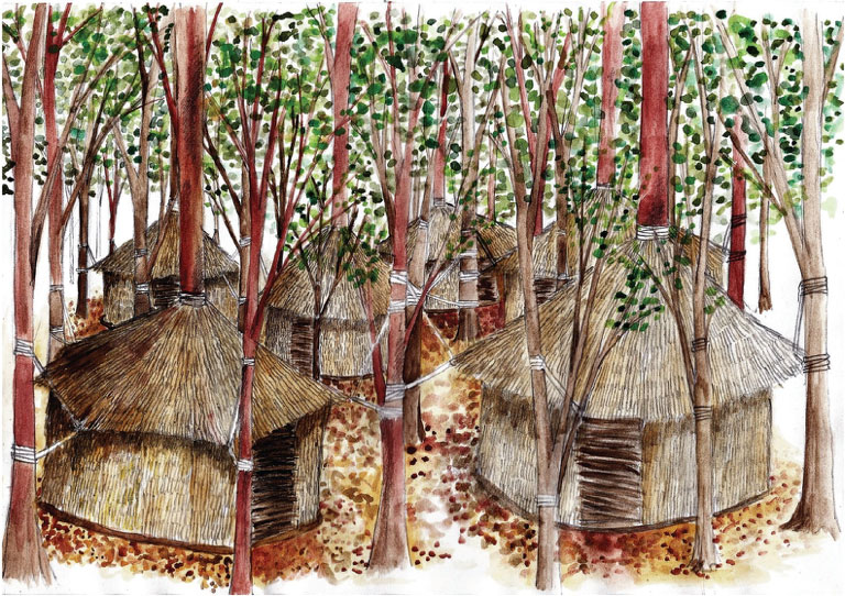
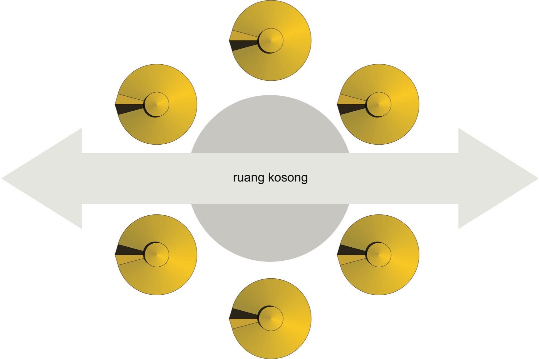
There were 6 until 8 houses for a period. The amount had to be even-numbered. The pattern of settlement was a circle, divided into 3-4 houses on the north side, 3-4 houses on the south, and the central area with the distance of approximately 3 meters to each side. This area was meant to be the crossing for the ancestors which should not be disturbed. With such approach, within the radius of 3 meters, all activities but rituals for the ancestors were prohibited.
Soak Lipur (South Land)
The settlement of Soak Lipur was located at the foot of Tajambibir Hill. Among all locations, this area was the most difficult to reach. However, it was very fertile. It impacted on the easier gathering of foodstuffs. Orang Aom spent most of the time by knitting ropes for the material of the house. The geographical condition of this land was the most comfortable among the other lands. Philosophically, this was the time for worldly pleasure. During this period, many artworks were created in the form of totem and artifact (mostly discovered around Tajambibir Hill).
The shape of the house was the most ideal yet complicated one compared to the other houses. What made it complicated was the structure that could not be easily dismantled. Moreover, the woods were more durable. Therefore, they had more time to make a more comfortable house. The main structure used a trunk with branches. The branches were entangled one another in A-shaped form. This combination of branches was then tied up. The shape of Uma Lipur was similar to a gable roof with extended ridge. It was a shape commonly found in other Austronesian houses because such shape was very effective to overcome the tropical climate. It became crucial since during their settlement in this location, the rainfall of the Triangle of Death was on a relatively high level.
Footnotes